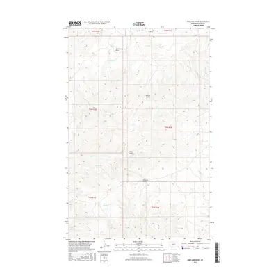
2017 Map of Shetland Divide
USGS Topo · Published 2017About this map
Shetland Divide serves as the prominent topographic spine of this Montana landscape, where the drainage patterns of Phillips County are clearly defined by intermittent creeks and coulees. Water management in this arid environment is evident through the presence of engineered catchments such as Dead Cedar Reservoir and Twin Snag Reservoir. The terrain is characterized by significant relief, including the elevated Saskatchewan Butte in the north and the deep incisions of Coyote Coulee and Hideaway Coulee to the south. These features reveal the complex erosion patterns common in the high plains. The map also documents seasonal water sources like Mud Spring and the winding paths of Winter Cr and Bull Cr, which dictate the local ecology and historical land use. North of the divide, Mitchell Rd provides one of the few named corridors through this open country.
Find a feature on this map
18 named features on this map. Tap any name to fly to it.
Don’t see what you’re looking for? This feature index may not catch every label — zoom into the map to look around manually.
Map Details
Editions of this 2017 Shetland Divide Map
This is the sole edition of this map. No revisions or reprints were ever made.
Other maps of this area

1943 · Landusky
USGS Topo · 1:125,000

1954 · Cow Island
USGS Topo · 1:24,000

1954 · Baker Monument
USGS Topo · 1:24,000

1954 · Bell Ridge West
USGS Topo · 1:24,000

1954 · Grand Island
USGS Topo · 1:24,000

1954 · Lewistown
USGS Topo · 1:250,000

1959 · Lewistown
USGS Topo · 1:250,000

1971 · Crazyman Coulee
USGS Topo · 1:24,000

1971 · Hays
USGS Topo · 1:24,000
1971 · John Coulee
USGS Topo · 1:24,000