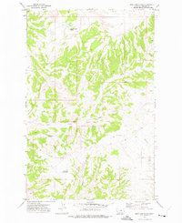
1971 Map of Shetland Divide
USGS Topo · Published 1975About this map
Shetland Divide forms the backbone of this high-plains landscape in Phillips County, Montana, separating the drainages of numerous seasonal waterways. The terrain is characterized by a series of long coulees and creeks that radiate from the central ridge, including Winter Creek, Bull Creek, and Coyote Coulee. To the north, the elevation culminates at Saskatchewan Butte, a prominent landmark overlooking the surrounding draws.
Find a feature on this map
18 named features on this map. Tap any name to fly to it.
Don’t see what you’re looking for? This feature index may not catch every label — zoom into the map to look around manually.
Map Details
Editions of this 1971 Shetland Divide Map
This is the sole edition of this map. No revisions or reprints were ever made.
Other maps of this area

1943 · Landusky
USGS Topo · 1:125,000

1954 · Cow Island
USGS Topo · 1:24,000

1954 · Baker Monument
USGS Topo · 1:24,000

1954 · Bell Ridge West
USGS Topo · 1:24,000

1954 · Grand Island
USGS Topo · 1:24,000

1954 · Lewistown
USGS Topo · 1:250,000

1959 · Lewistown
USGS Topo · 1:250,000

1971 · Crazyman Coulee
USGS Topo · 1:24,000

1971 · Hays
USGS Topo · 1:24,000
1971 · John Coulee
USGS Topo · 1:24,000