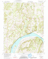
1959 Map of Shetlerville
USGS Topo · Published 1991About this map
The Ohio River dominates the southern landscape of this 1959 survey, serving as the border between Illinois and Kentucky. Near the riverbank, the small riverfront settlement of Shetlerville sits adjacent to the high ground of Rich Hill, while Carrsville occupies the opposite shore in Kentucky. The interior topography is characterized by a series of hollows and ridges within the Shawnee National Forest, including Hurricane Hollow and Giddeonson Hollow. Local industry and rural infrastructure are visible through features like the Stewart Mine, a Quarry, and the Illinois Central railroad line, which meets at Humm Wye. Genealogists will find numerous family burial sites throughout the hills, such as Vaught Cem, Soward Cem, and Thompson Cem, alongside community landmarks like St Joseph Ch and Union Ch.
Find a feature on this map
63 named features on this map. Tap any name to fly to it.
Don’t see what you’re looking for? This feature index may not catch every label — zoom into the map to look around manually.
Map Details
Editions of this 1959 Shetlerville Map
3 editions found
Other maps of this area

1916 · Golconda
USGS Topo · 1:62,500

1916 · Equality
USGS Topo · 1:62,500

1917 · Brownfield
USGS Topo · 1:62,500

1920 · Goloonda
USGS Topo · 1:48,000

1921 · Golconda
USGS Topo · 1:62,500

1925 · Harrisburg
USGS Topo · 1:62,500

1939 · Harrisburg
USGS Topo · 1:62,500

1949 · Paducah
USGS Topo · 1:250,000

1950 · Paducah
USGS Topo · 1:250,000

1954 · Paducah
USGS Topo · 1:250,000