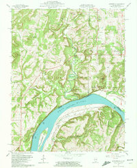
1959 Map of Shetlerville
USGS Topo · Published 1972About this map
Shetlerville and the riverfront town of Carrsville flank the Ohio River in this detailed survey of the borderlands between Illinois and Kentucky. The landscape is defined by the sharp transition from the wooded ridges of the Shawnee National Forest to the wide river valley. Deeply carved drainages like Big Grand Pierre Creek and Threemile Creek feed into the river, which features the prominent Rondeau Island near the Kentucky shore. Evidence of local industry is scattered throughout the hills, from the Baker Mine and Stewart Mine in the north to the Parkinson Mine near the center of the sheet.
Find a feature on this map
60 named features on this map. Tap any name to fly to it.
Don’t see what you’re looking for? This feature index may not catch every label — zoom into the map to look around manually.
Map Details
Editions of this 1959 Shetlerville Map
3 editions found
Other maps of this area

1916 · Golconda
USGS Topo · 1:62,500

1916 · Equality
USGS Topo · 1:62,500

1917 · Brownfield
USGS Topo · 1:62,500

1920 · Goloonda
USGS Topo · 1:48,000

1921 · Golconda
USGS Topo · 1:62,500

1925 · Harrisburg
USGS Topo · 1:62,500

1939 · Harrisburg
USGS Topo · 1:62,500

1949 · Paducah
USGS Topo · 1:250,000

1950 · Paducah
USGS Topo · 1:250,000

1954 · Paducah
USGS Topo · 1:250,000