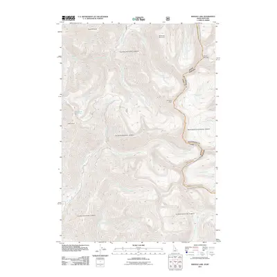
2011 Map of Shewag Lake
USGS Topo · Published 2011About this map
Eagle Mountain and the high peaks of the Bitterroot Mountain range anchor this mountainous drainage divide along the Idaho-Montana border. The landscape is defined by a dense network of high-elevation watercourses, including the headwaters of Sheep Creek, Pruvan Creek, and Blacktail Creek. Near the center of the sheet, the Fourth of July Creek Rd provides limited access through the rugged terrain, passing south of Shewag Lake and the prominent N Mountain. The hydrography here is particularly detailed, tracing the complex descent of Fourth of July Creek and its many tributaries as they flow through deep mountain valleys. This 2011 survey captures the area’s topographic character prior to any significant modern development, emphasizing natural features like Pyramid Peak and Sheep Mountain that have long served as landmarks for backcountry navigation and land management.
Find a feature on this map
20 named features on this map. Tap any name to fly to it.
Don’t see what you’re looking for? This feature index may not catch every label — zoom into the map to look around manually.
Map Details
Editions of this 2011 Shewag Lake Map
This is the sole edition of this map. No revisions or reprints were ever made.
Other maps of this area

1955 · Dillon
USGS Topo · 1:250,000

1957 · Dillon
USGS Topo · 1:250,000

1958 · Dillon
USGS Topo · 1:250,000

1962 · Dillon
USGS Topo · 1:250,000

1965 · Dillon
USGS Topo · 1:250,000

1966 · Badger Spring Gulch
USGS Topo · 1:24,000

1966 · Shewag Lake
USGS Topo · 1:24,000

1966 · Jumbo Mountain
USGS Topo · 1:24,000

1966 · Big Hole Pass
USGS Topo · 1:24,000
1966 · Isaac Meadows
USGS Topo · 1:24,000