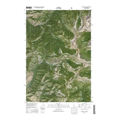
2013 Map of Shewag Lake
USGS Topo · Published 2013About this map
The Continental Divide serves as the high-altitude spine of this map, marking the jagged boundary between Idaho and Montana. This high-country region is divided between the Salmon National Forest and the Beaverhead National Forest, characterized by steep drainages and prominent summits like Eagle Mtn and Pyramid Peak. The hydrology is particularly complex here, with headwater streams such as Shewag Cr and the N Fork Sheep Cr radiating from the peaks. The namesake Shewag Lake sits tucked into a glacial cirque below N Mtn, providing a focal point for this wilderness landscape. Human presence is minimal, primarily represented by the Fourth of July Creek Rd and a network of drainages like Cassel Gulch and Elkhorn Gulch that hint at the area's prospecting and grazing history.
Find a feature on this map
35 named features on this map. Tap any name to fly to it.
Don’t see what you’re looking for? This feature index may not catch every label — zoom into the map to look around manually.
Map Details
Editions of this 2013 Shewag Lake Map
This is the sole edition of this map. No revisions or reprints were ever made.
Other maps of this area

1955 · Dillon
USGS Topo · 1:250,000

1957 · Dillon
USGS Topo · 1:250,000

1958 · Dillon
USGS Topo · 1:250,000

1962 · Dillon
USGS Topo · 1:250,000

1965 · Dillon
USGS Topo · 1:250,000

1966 · Badger Spring Gulch
USGS Topo · 1:24,000

1966 · Shewag Lake
USGS Topo · 1:24,000

1966 · Jumbo Mountain
USGS Topo · 1:24,000

1966 · Big Hole Pass
USGS Topo · 1:24,000
1966 · Isaac Meadows
USGS Topo · 1:24,000