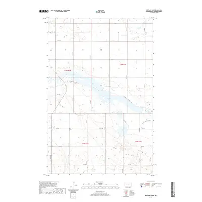
2018 Map of Sheyenne Lake
USGS Topo · Published 2018About this map
Sheyenne Lake and Coal Mine Lake dominate this Sheridan County landscape, where the prairie is carved by the headwaters of the Sheyenne River. The 2018 survey reveals a terrain defined by glacial depressions and seasonal water bodies, including Lone Tree Lake. Tracing through the center of the sheet, the N Country National Scenic Trail follows the northern and southern rims of these major lakes, offering a continuous path through the rolling topography of central North Dakota. Cultural landmarks are sparse in this rural area, centered primarily on the historic Saint Emanuel Cem located south of the main lake complex. The township grid, marked by sections in t149n r75w and t149n r74w, highlights the orderly division of this prairie region, where section lines are often mirrored by the network of local roads like 18th St NE and 17th Ave NE.
Find a feature on this map
26 named features on this map. Tap any name to fly to it.
Don’t see what you’re looking for? This feature index may not catch every label — zoom into the map to look around manually.
Map Details
Editions of this 2018 Sheyenne Lake Map
This is the sole edition of this map. No revisions or reprints were ever made.
Other maps of this area

1930 · Drake
USGS Topo · 1:62,500

1940 · Aylmer
USGS Topo · 1:62,500

1946 · Sheyenne Lake
USGS Topo · 1:48,000

1947 · Lincoln Valley
USGS Topo · 1:62,500

1947 · Sheyenne Lake
USGS Topo · 1:62,500

1950 · Sheyenne Lake NE
USGS Topo · 1:24,000

1950 · Sheyenne Lake
USGS Topo · 1:24,000

1951 · Martin
USGS Topo · 1:24,000

1951 · Anamoose SW
USGS Topo · 1:24,000

1954 · McClusky
USGS Topo · 1:250,000