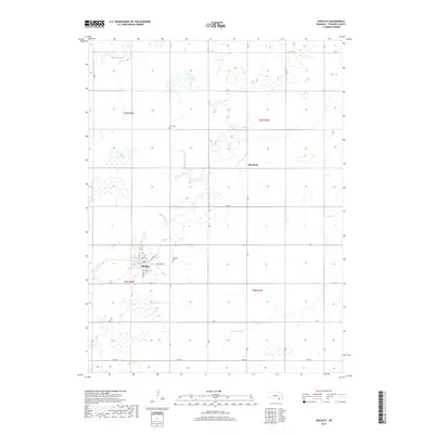
2017 Map of Shickley
USGS Topo · Published 2017About this map
Shickley serves as the central hub of this agricultural landscape in Fillmore County, where the street grid is clearly defined by routes like N Plum St and S Railroad St. The surrounding terrain is characterized by a series of depressions and water bodies, most notably Weis Lagoon and the winding course of Turkey Cr to the north. These features are indicative of the rainwater basin region, where seasonal wetlands provide critical habitat within the intensive farming sections of the plains. Historical continuity is marked by local landmarks such as the Shickley Cem just east of town and Zion Cem further north. To the east, the small settlement of Martland sits along the section lines, while Dry Sandy Cr cuts through the southern reaches of the quadrangle, illustrating the drainage patterns that define this part of the Nebraska prairie.
Find a feature on this map
29 named features on this map. Tap any name to fly to it.
Don’t see what you’re looking for? This feature index may not catch every label — zoom into the map to look around manually.
Map Details
Editions of this 2017 Shickley Map
This is the sole edition of this map. No revisions or reprints were ever made.
Other maps of this area

1898 · York
USGS Topo · 1:125,000

1898 · Hebron
USGS Topo · 1:125,000

1899 · York
USGS Topo · 1:125,000

1955 · Lincoln
USGS Topo · 1:250,000

1957 · Lincoln
USGS Topo · 1:250,000

1958 · Lincoln
USGS Topo · 1:250,000

1960 · Bruning
USGS Topo · 1:24,000

1960 · Davenport
USGS Topo · 1:24,000

1960 · Carleton
USGS Topo · 1:24,000
1969 · Ong
USGS Topo · 1:24,000