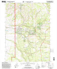
1993 Map of Shields Creek
USGS Topo · Published 1996About this map
Modoc National Forest dominates this high-elevation landscape in northeastern California, where the Warner Mountains Wilderness meets managed forest lands and a designated State Game Refuge. The topography is defined by a series of dramatic canyons and gulches, including White Horse Canyon and Payne Canyon, which funnel water into Parker Creek and Shields Creek. These drainage patterns are central to the area's utility, as seen at the Porter Reservoir, an essential water management feature for this arid environment.
Find a feature on this map
30 named features on this map. Tap any name to fly to it.
Don’t see what you’re looking for? This feature index may not catch every label — zoom into the map to look around manually.
Map Details
Editions of this 1993 Shields Creek Map
This is the sole edition of this map. No revisions or reprints were ever made.
Other maps of this area

1886 · Alturas
USGS Topo · 1:250,000

1892 · Alturas
USGS Topo · 1:250,000

1954 · Alturas
USGS Topo · 1:250,000

1958 · Alturas
USGS Topo · 1:250,000

1962 · Alturas
USGS Topo · 1:250,000

1962 · Davis Creek
USGS Topo · 1:62,500

1962 · Cedarville
USGS Topo · 1:62,500

1963 · Warren Peak
USGS Topo · 1:24,000

1963 · Little Juniper Reservoir
USGS Topo · 1:24,000

1963 · Shields Creek
USGS Topo · 1:24,000