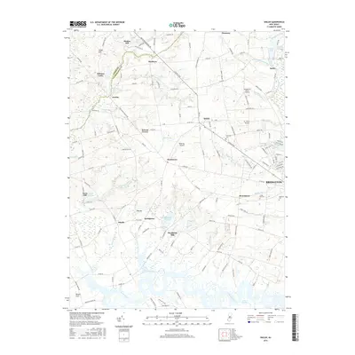
2016 Map of Shiloh
USGS Topo · Published 2016About this map
The western edges of Bridgeton meet the agricultural heart of Cumberland County in this 2016 survey, where the Cohansey River winds through the Green Swamp toward the Delaware Bay. The landscape is defined by its long-standing milling history and rural crossroads, with old sites like Mickles Mill and Sheppards Mill appearing alongside established settlements such as Shiloh and Roadstown. Significant water bodies including Mary Elmer Lake, Elk Lake, and Sheppards Millpond illustrate the drainage patterns that once powered local industry. Aviation has also left its mark on these fields, evidenced by the Wide Sky Airpark and B J Farms Airport. For those tracing local roots, several major burial grounds are documented, including Fernwood Cem, Cedar Hill Cem, and Overlook Cem. The map provides a contemporary view of these historic communities, from the residential streets of Bridgeton to the outlying houses at Bacons Neck and Jericho.
Find a feature on this map
152 named features on this map. Tap any name to fly to it.
Don’t see what you’re looking for? This feature index may not catch every label — zoom into the map to look around manually.
Map Details
Editions of this 2016 Shiloh Map
This is the sole edition of this map. No revisions or reprints were ever made.
Other maps of this area

1890 · Salem
USGS Topo · 1:62,500

1890 · Bay Side
USGS Topo · 1:62,500

1890 · Bridgeton
USGS Topo · 1:62,500

1890 · Glassboro
USGS Topo · 1:62,500

1894 · Bay Side
USGS Topo · 1:62,500

1894 · Bridgeton
USGS Topo · 1:62,500

1898 · Salem
USGS Topo · 1:62,500

1898 · Glassboro
USGS Topo · 1:62,500

1899 · Vineland
USGS Topo · 1:125,000

1901 · Camden
USGS Topo · 1:125,000
Featured Places
- Bridgeton, NJ
- Fairfield Township, NJ
- Hopewell Township, NJ
- Quinton Township, NJ
- Lower Alloways Creek Township, NJ