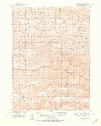
1950 Map of Shimmins Lake
USGS Topo · Published 1950About this map
The Dismal River meanders across this landscape in the heart of the Nebraska Sandhills, defining the drainage patterns of central Hooker County and Thomas County. Surveyed in the late 1940s, this area is characterized by its sparse population and an distribution of rural education centers, including Daggett Sch, Madron Sch, and Rodewald Sch. These schoolhouses, alongside others like Sch No 11, highlight a time when local education was decentralized across the sprawling ranching terrain. Near the southwestern corner, the eponymous Shimmins Lake provides a primary water feature in an otherwise arid expanse. The map illustrates the 1950 status of primitive roads and section lines that connected these remote homesteads and school districts long before the consolidation of modern rural infrastructure.
Find a feature on this map
13 named features on this map. Tap any name to fly to it.
Don’t see what you’re looking for? This feature index may not catch every label — zoom into the map to look around manually.
Map Details
Editions of this 1950 Shimmins Lake Map
2 editions found

Other maps of this area

1947 · Dismal River Ranch
USGS Topo · 1:62,500

1948 · Seneca
USGS Topo · 1:62,500

1948 · Thedford
USGS Topo · 1:62,500

1948 · Mullen
USGS Topo · 1:62,500

1948 · Seneca 4
USGS Topo · 1:62,500

1949 · Seneca 4
USGS Topo · 1:62,500

1949 · Dismal River Ranch
USGS Topo · 1:62,500

1949 · Cody Lake
USGS Topo · 1:62,500

1949 · Wright Valley
USGS Topo · 1:62,500

1950 · Thedford
USGS Topo · 1:62,500