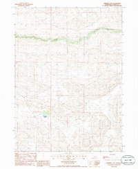
1985 Map of Shimmins Lake
USGS Topo · Published 1986About this map
Dismal River carves a winding path through the undulating sand hills of Hooker County in this mid-1980s topographic study. The landscape is characterized by a high density of depressions and ridges, typical of the Nebraska Sandhills, where water is a sparse but vital feature. Shimmins Lake sits as a primary landmark in the southern half of the sheet, surrounded by a complex network of unimproved roads and trails that navigate the shifting terrain. This provisional survey captures the area at a moment when cattle ranching and land management relied on these remote tracks, far from established towns. The lack of named settlements emphasizes the isolation of this ranching country, where small bodies of water and the central river corridor dictate the movement of people and livestock across the township lines of t22n and t21n.
Find a feature on this map
4 named features on this map. Tap any name to fly to it.
Don’t see what you’re looking for? This feature index may not catch every label — zoom into the map to look around manually.
Map Details
Editions of this 1985 Shimmins Lake Map
This is the sole edition of this map. No revisions or reprints were ever made.
Other maps of this area

1947 · Dismal River Ranch
USGS Topo · 1:62,500

1949 · Dismal River Ranch
USGS Topo · 1:62,500

1949 · Wright Valley
USGS Topo · 1:62,500

1950 · Shimmins Lake
USGS Topo · 1:62,500

1951 · Tryon
USGS Topo · 1:62,500

1951 · Wright Valley
USGS Topo · 1:62,500

1954 · North Platte
USGS Topo · 1:250,000

1956 · North Platte
USGS Topo · 1:250,000

1957 · North Platte
USGS Topo · 1:250,000

1967 · North Platte
USGS Topo · 1:250,000