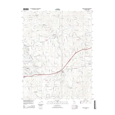
2015 Map of Shingle Springs
USGS Topo · Published 2015About this map
Shingle Springs and the surrounding foothill settlements are documented in this 2015 topographic study, reflecting a landscape where historical ranching and mining roots meet modern aviation and recreation. The El Dorado Trail cuts through the center of the map, following a path that parallels the historic corridor connecting Cameron Park to Kingsville. For genealogists and local historians, the Jayhawk Cemetery remains a significant landmark near the small settlement of Jayhawk, while other named locales like Spreckelsville, White Oak Flat, and Frenchtown indicate the persistent identity of these communities.
Find a feature on this map
266 named features on this map. Tap any name to fly to it.
Don’t see what you’re looking for? This feature index may not catch every label — zoom into the map to look around manually.
Map Details
Editions of this 2015 Shingle Springs Map
This is the sole edition of this map. No revisions or reprints were ever made.
Other maps of this area

1891 · Sacramento
USGS Topo · 1:125,000

1891 · Placerville
USGS Topo · 1:125,000

1892 · Sacramento
USGS Topo · 1:125,000

1892 · Placerville
USGS Topo · 1:125,000

1893 · Placerville
USGS Topo · 1:125,000

1893 · Sacramento
USGS Topo · 1:125,000

1941 · Folsom
USGS Topo · 1:62,500
1944 · Auburn
USGS Topo · 1:62,500
1944 · Folsom
USGS Topo · 1:62,500

1947 · Sacramento
USGS Topo · 1:250,000