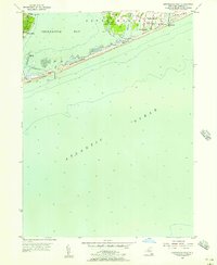
1955 Map of Shinnecock Inlet
USGS Topo · Published 1957About this map
Shinnecock Indian Reservation occupies a central position on this coastal survey, preserving a community landscape that includes the Shinnecock Indian Cem and Shinnecock Sch. To the east, the village of Southampton is detailed with its distinctive residential street grid, featuring historic thoroughfares like Halsey Neck Lane and Gin Lane leading toward the coast. The map illustrates the precarious barrier beach system, from Tiana Sand Beach to Southampton Beach, separated from the mainland by the expanse of Shinnecock Bay.
Find a feature on this map
25 named features on this map. Tap any name to fly to it.
Don’t see what you’re looking for? This feature index may not catch every label — zoom into the map to look around manually.
Map Details
Editions of this 1955 Shinnecock Inlet Map
3 editions found
Other maps of this area

1903 · Sag Harbor
USGS Topo · 1:62,500

1903 · Riverhead
USGS Topo · 1:62,500

1904 · Sag Harbor
USGS Topo · 1:62,500

1904 · Riverhead
USGS Topo · 1:62,500

1943 · Riverhead
USGS Topo · 1:62,500

1946 · Sag Harbor
USGS Topo · 1:24,000

1947 · Mattituck
USGS Topo · 1:24,000

1947 · Southampton
USGS Topo · 1:24,000

1947 · Quogue
USGS Topo · 1:24,000
1947 · Shinnecock Bay
USGS Topo · 1:24,000