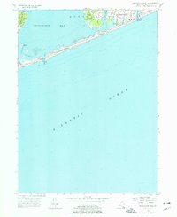
1955 Map of Shinnecock Inlet
USGS Topo · Published 1976About this map
The Shinnecock Indian Reservation occupies a prominent peninsula on this 1950s survey, documenting the ancestral lands and community structures including the Shinnecock Sch and the Shinnecock Indian Cem. To the east, the established village of Southampton is characterized by its coastal lakes and ponds, such as Agawam Lake and Coopers Neck Pond, which sit just inland from the Atlantic.
Find a feature on this map
24 named features on this map. Tap any name to fly to it.
Don’t see what you’re looking for? This feature index may not catch every label — zoom into the map to look around manually.
Map Details
Editions of this 1955 Shinnecock Inlet Map
3 editions found
Other maps of this area

1903 · Sag Harbor
USGS Topo · 1:62,500

1903 · Riverhead
USGS Topo · 1:62,500

1904 · Sag Harbor
USGS Topo · 1:62,500

1904 · Riverhead
USGS Topo · 1:62,500

1943 · Riverhead
USGS Topo · 1:62,500

1946 · Sag Harbor
USGS Topo · 1:24,000

1947 · Mattituck
USGS Topo · 1:24,000

1947 · Southampton
USGS Topo · 1:24,000

1947 · Quogue
USGS Topo · 1:24,000
1947 · Shinnecock Bay
USGS Topo · 1:24,000