
1954 Map of Shinumo Altar
USGS Topo · Published 1956About this map
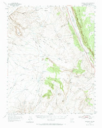
The Navajo Indian Reservation landscape is defined here by the dramatic rise of the Echo Cliffs, which separate the high Kaibito Plateau from the arid lowlands to the west. In the mid-1950s, this area remained an expansive territory of nomadic grazing and isolated outposts, centered around the Cedar Ridge Trading Post. Water management is the primary evidence of human activity on the land, with numerous small catchments like Blue Moon Reservoir, McClellan Tanks, and Eagle Nest Reservoir dotting the drainages of Hogansaani Wash and Tanner Wash. The topography is marked by distinctive geological formations such as the Shinumo Altar and the Yon Dot Mountains, while cattle operations are evidenced by features like Yellow Door Corral and the Rock Corral Bench. This survey captures a specific era of land use before modern infrastructure reached deep into this corner of Coconino County.
Find a feature on this map
51 named features on this map. Tap any name to fly to it.
Don’t see what you’re looking for? This feature index may not catch every label — zoom into the map to look around manually.
Map Details
Editions of this 1954 Shinumo Altar Map
2 editions found
Other maps of this area

1886 · Echo Cliffs
USGS Topo · 1:250,000

1891 · Echo Cliffs
USGS Topo · 1:250,000

1907 · Vishnu
USGS Topo · 1:48,000

1954 · Shinumo Altar NE
USGS Topo · 1:24,000

1954 · Shinumo Altar SE
USGS Topo · 1:24,000

1954 · Nankoweap
USGS Topo · 1:62,500

1954 · Tanner Wash
USGS Topo · 1:62,500

1954 · Emmett Wash
USGS Topo · 1:62,500

1955 · Blue Spring NE
USGS Topo · 1:24,000

1955 · Moa Ave NW
USGS Topo · 1:24,000