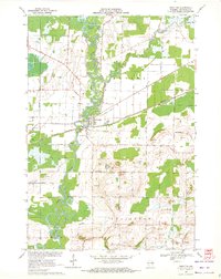
1969 Map of Shiocton
USGS Topo · Published 1972About this map
The Wolf River defines the landscape of this Outagamie County region, winding through the townships of Bovina, Liberty, and Ellington. The village of Shiocton serves as a central hub where the river meets the Green Bay and Western railroad and the Shioc River. This era shows a significant commitment to conservation and public land, evidenced by the large Mack State Wildlife Area and Outagamie State Wildlife Area that flank the river's path. Local infrastructure in the late 1960s was supported by a network of rural roads such as Koepke Road and Rexford Road, while historical markers like Bovina Cem, Rexford Cem, and the central Townhall anchor the community's genealogy. Numerous sandpits dot the terrain, particularly south of the village, indicating the local industrial activity of the period.
Find a feature on this map
46 named features on this map. Tap any name to fly to it.
Don’t see what you’re looking for? This feature index may not catch every label — zoom into the map to look around manually.
Map Details
Editions of this 1969 Shiocton Map
2 editions found
Other maps of this area

1955 · Embarrass
USGS Topo · 1:48,000

1955 · Appleton
USGS Topo · 1:24,000

1955 · Appleton
USGS Topo · 1:62,500

1955 · Seymour
USGS Topo · 1:62,500

1955 · Green Bay
USGS Topo · 1:250,000

1956 · New London
USGS Topo · 1:48,000

1969 · New London
USGS Topo · 1:24,000
1969 · Hortonville
USGS Topo · 1:24,000

1969 · Leeman
USGS Topo · 1:24,000

1969 · Bear Creek
USGS Topo · 1:24,000