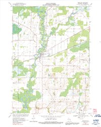
1969 Map of Shiocton
USGS Topo · Published 1992About this map
The Wolf River winds in tight oxbows through this landscape, defining the character of Shiocton and the surrounding townships of Bovina and Ellington. This 1969 survey, photoinspected in 1982, shows a transition from the structured grid of rural roads like Koepke Road and Bischoff Road to the wetlands and marshes protected within the Outagamie State Wildlife Area. The Green Bay and Western railroad cuts a straight diagonal through the terrain, passing just south of the village center near Hamlin Park. Local history is preserved in the locations of the Bovina Cem and Rexford Cem, while the industrial footprint of the era is marked by numerous Sandpits scattered across the southern half of the quadrangle. The confluence of the Shioc River and the Wolf River serves as a focal point for the region's geography and drainage patterns.
Find a feature on this map
42 named features on this map. Tap any name to fly to it.
Don’t see what you’re looking for? This feature index may not catch every label — zoom into the map to look around manually.
Map Details
Editions of this 1969 Shiocton Map
2 editions found
Other maps of this area

1955 · Embarrass
USGS Topo · 1:48,000

1955 · Appleton
USGS Topo · 1:24,000

1955 · Appleton
USGS Topo · 1:62,500

1955 · Seymour
USGS Topo · 1:62,500

1955 · Green Bay
USGS Topo · 1:250,000

1956 · New London
USGS Topo · 1:48,000

1969 · New London
USGS Topo · 1:24,000
1969 · Hortonville
USGS Topo · 1:24,000

1969 · Leeman
USGS Topo · 1:24,000

1969 · Bear Creek
USGS Topo · 1:24,000