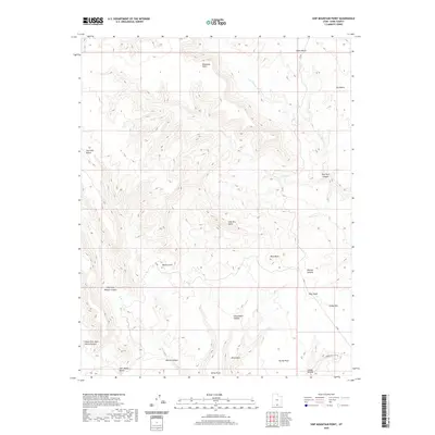
2020 Map of Ship Mountain Point
USGS Topo · Published 2020About this map
Ship Mtn Point and Smoky Mtn dominate this high-desert plateau landscape in southern Utah, where the topography is defined by a series of prominent benches and deep, winding canyons. The drainages of Last Chance Cr and East Chance Cr carve through the northern flats, while the southern reaches fall away into the complex network of Wesses Canyon and Stony Point Canyon. Human presence is minimal, marked primarily by remote routes like Smokey Hollow Rd and the presence of cattle-related infrastructure such as Drip Tank. The map reveals a land of dramatic vertical shifts, from the broad expanse of Fourmile Bench to the isolated heights of Pilot Rock and Pilot Knoll, illustrating the erosional forces that have shaped this portion of the Colorado Plateau.
Find a feature on this map
26 named features on this map. Tap any name to fly to it.
Don’t see what you’re looking for? This feature index may not catch every label — zoom into the map to look around manually.
Map Details
Editions of this 2020 Ship Mountain Point Map
This is the sole edition of this map. No revisions or reprints were ever made.
Other maps of this area

1886 · Escalante
USGS Topo · 1:250,000

1922 · Warm Creek
USGS Topo · 1:63,360

1922 · Upper Last Chance
USGS Topo · 1:63,360

1922 · Rees Canyon
USGS Topo · 1:63,360

1953 · Nipple Butte
USGS Topo · 1:62,500

1953 · Gunsight Butte
USGS Topo · 1:62,500

1956 · Escalante
USGS Topo · 1:250,000

1960 · Escalante
USGS Topo · 1:250,000

1968 · Fourmile Bench
USGS Topo · 1:24,000
1968 · Petes Cove
USGS Topo · 1:24,000