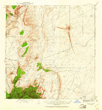
1934 Map of Ship Rock
USGS Topo · Published 1961About this map
Ship Rock towers as the primary landmark of this high-desert landscape within the Navajo Indian Reservation during the mid-1930s. The topography is defined by sharp volcanic features and steep ridgelines, including Red Rock Ridge and the Beautiful Mountains along the border of Apache and San Juan Counties. While modern infrastructure is sparse, the Red Rock Highway provides a primary transit corridor through the arid terrain, connecting isolated water sources like Sheep Spring and Mud Spring.
Find a feature on this map
18 named features on this map. Tap any name to fly to it.
Don’t see what you’re looking for? This feature index may not catch every label — zoom into the map to look around manually.
Map Details
Editions of this 1934 Ship Rock Map
4 editions found
Other maps of this area

1889 · Chaco
USGS Topo · 1:250,000

1892 · Chaco
USGS Topo · 1:250,000

1892 · Canyon De Chelly
USGS Topo · 1:250,000

1927 · Sulphur Spring
USGS Topo · 1:96,000

1928 · Kirtland
USGS Topo · 1:125,000

1932 · Kirtland
USGS Topo · 1:125,000

1934 · Ship Rock
USGS Topo · 1:62,500

1934 · Chimney Rock
USGS Topo · 1:62,500

1934 · Rattlesnake
USGS Topo · 1:62,500

1936 · Chimney Rock
USGS Topo · 1:62,500