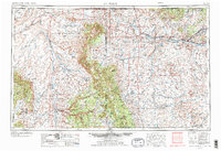
1954 Map of Shiprock
USGS Topo · Published 1973About this map
Ship Rock stands as the defining landmark of this high-desert landscape, anchored within the extensive boundaries of the Navajo Indian Reservation. This survey from the mid-1950s captures the distribution of Indigenous communities across the Four Corners region, connecting settlements like Teec Nos Pos, Sanostee, and Toadlena through a network of emerging highways. The topography transitions from the dramatic spires of Mitten Rock and Pastora Peak to the deeply carved terrain of the Canyon de Chelly. To the east, the San Juan River corridor supports the growing population centers of Farmington, Kirtland, and Fruitland, where irrigation and the proximity of an Oil Field and Gas Field reflect a shifting economy. Water management is evident through features such as Morgan Lake and Wheatfields Lake, which provide critical resources in an arid environment shaped by Comb Ridge and the Chuska Mountains.
Find a feature on this map
67 named features on this map. Tap any name to fly to it.
Don’t see what you’re looking for? This feature index may not catch every label — zoom into the map to look around manually.
Map Details
Editions of this 1954 Shiprock Map
5 editions found

Other maps of this area

1883 · Marsh Pass
USGS Topo · 1:250,000

1883 · Mt. Taylor
USGS Topo · 1:250,000

1883 · Tusayan
USGS Topo · 1:250,000

1886 · Wingate
USGS Topo · 1:250,000

1886 · Mt. Taylor
USGS Topo · 1:250,000

1886 · Tusayan
USGS Topo · 1:250,000

1886 · Fort Defiance
USGS Topo · 1:250,000

1886 · Henry Mountains
USGS Topo · 1:250,000

1886 · Abajo
USGS Topo · 1:250,000

1889 · Largo
USGS Topo · 1:250,000