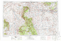
1954 Map of Shiprock
USGS Topo · Published 1973About this map
The Shiprock volcanic formation towers over the high desert of the Four Corners region, a landscape dominated by the Navajo Indian Reservation and the rising Carrizo Mountains. In the mid-1950s, the San Juan River corridor supported growing hubs at Farmington and Fruitland, while the vast interiors remained connected by landmarks like the Shiprock Trading Post and Carson Trading Post. The topography transitions from the dramatic Canyon de Chelly National Monument in the west to the deep cuts of Gallegos Canyon in the east. This era shows the intersection of traditional land use and emerging industrial footprints, evidenced by the Oil Field and Gas Field developments near the Hogback. The survey detail captures isolated settlements such as Teec Nos Pos, Many Farms, and Crystal, situated along the winding routes of Chinle Wash and Laguna Creek.
Find a feature on this map
78 named features on this map. Tap any name to fly to it.
Don’t see what you’re looking for? This feature index may not catch every label — zoom into the map to look around manually.
Map Details
Editions of this 1954 Shiprock Map
5 editions found

Other maps of this area

1883 · Marsh Pass
USGS Topo · 1:250,000

1883 · Mt. Taylor
USGS Topo · 1:250,000

1883 · Tusayan
USGS Topo · 1:250,000

1886 · Wingate
USGS Topo · 1:250,000

1886 · Mt. Taylor
USGS Topo · 1:250,000

1886 · Tusayan
USGS Topo · 1:250,000

1886 · Fort Defiance
USGS Topo · 1:250,000

1886 · Henry Mountains
USGS Topo · 1:250,000

1886 · Abajo
USGS Topo · 1:250,000

1889 · Largo
USGS Topo · 1:250,000