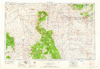
1954 Map of Shiprock
USGS Topo · Published 1963About this map
The Chuska Mountains and Lukachukai Mountains form a high-altitude spine across this section of the high desert, anchoring a landscape defined by traditional Navajo land use and federal designations. Early 1960s infrastructure is centered on the San Juan River valley, where Farmington, Fruitland, and Kirtland represent the primary population centers. Beyond these settlements, the map reveals a vast network of trading posts and missions that served as vital social and economic hubs for the Navajo Indian Reservation, including the Chinle Valley Trading Post and the Rock Point Mission.
Find a feature on this map
94 named features on this map. Tap any name to fly to it.
Don’t see what you’re looking for? This feature index may not catch every label — zoom into the map to look around manually.
Map Details
Editions of this 1954 Shiprock Map
5 editions found

Other maps of this area

1883 · Marsh Pass
USGS Topo · 1:250,000

1883 · Mt. Taylor
USGS Topo · 1:250,000

1883 · Tusayan
USGS Topo · 1:250,000

1886 · Wingate
USGS Topo · 1:250,000

1886 · Mt. Taylor
USGS Topo · 1:250,000

1886 · Tusayan
USGS Topo · 1:250,000

1886 · Fort Defiance
USGS Topo · 1:250,000

1886 · Henry Mountains
USGS Topo · 1:250,000

1886 · Abajo
USGS Topo · 1:250,000

1889 · Largo
USGS Topo · 1:250,000