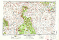
1954 Map of Shiprock
USGS Topo · Published 1973About this map
The Ship Rock formation stands as a central landmark in this mid-century survey of the Four Corners region, where the high desert terrain meets industrial expansion. The landscape is defined by the massive Lukachukai Mountains and Chuska Mountains, which transition into the extensive Navajo Indian Reservation. Along the San Juan River, communities like Farmington, Kirtland, and Fruitland show the established settlement patterns of the river valley. To the west, the intricate topography of Canyon De Chelly National Monument is detailed alongside early energy development infrastructure. Visible markers like the powerplant near Morgan Lake and numerous gas and oil fields east of Farmington document the region's evolving economy during the 1950s and 1960s. These industrial sites contrast with traditional centers such as the trading posts found at Teec Nos Pos and Crystal.
Find a feature on this map
83 named features on this map. Tap any name to fly to it.
Don’t see what you’re looking for? This feature index may not catch every label — zoom into the map to look around manually.
Map Details
Editions of this 1954 Shiprock Map
5 editions found

Other maps of this area

1883 · Marsh Pass
USGS Topo · 1:250,000

1883 · Mt. Taylor
USGS Topo · 1:250,000

1883 · Tusayan
USGS Topo · 1:250,000

1886 · Wingate
USGS Topo · 1:250,000

1886 · Mt. Taylor
USGS Topo · 1:250,000

1886 · Tusayan
USGS Topo · 1:250,000

1886 · Fort Defiance
USGS Topo · 1:250,000

1886 · Henry Mountains
USGS Topo · 1:250,000

1886 · Abajo
USGS Topo · 1:250,000

1889 · Largo
USGS Topo · 1:250,000