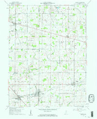
1960 Map of Shirley
USGS Topo · Published 1961About this map
Markleville and Shirley anchor this agricultural region during a period of steady Midwestern development where the borders of Madison, Henry, and Hancock counties converge. The local economy and social life are structured around the New York Central railroad corridor, which links the towns of Wilkinson and Kennard. The landscape is defined by an intricate network of drainage and creek systems, including Fall Creek, Sugar Creek, and numerous agricultural ditches like the Van Meter Ditch and Pierce Ditch, reflecting the intensive land management required for the area's corn and grain production.
Find a feature on this map
53 named features on this map. Tap any name to fly to it.
Don’t see what you’re looking for? This feature index may not catch every label — zoom into the map to look around manually.
Map Details
Editions of this 1960 Shirley Map
2 editions found
Other maps of this area

1949 · New Castle West
USGS Topo · 1:24,000

1950 · Dunreith
USGS Topo · 1:24,000

1952 · Anderson
USGS Topo · 1:24,000

1953 · Pendleton
USGS Topo · 1:24,000

1953 · Cincinnati
USGS Topo · 1:250,000

1953 · Muncie
USGS Topo · 1:250,000

1956 · Muncie
USGS Topo · 1:250,000

1956 · Cleveland
USGS Topo · 1:24,000

1957 · Cincinnati
USGS Topo · 1:250,000

1960 · New Castle West
USGS Topo · 1:24,000