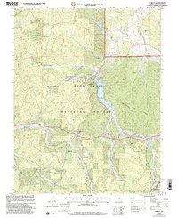
1999 Map of Shirley
USGS Topo · Published 2002About this map
Sunnen Lake and the Mark Twain National Forest dominate the central landscape of this Washington County survey. The settlement of Shirley is a focal point of the area's rural social infrastructure, supported by the Shirley School and the nearby White Oak Grove Church. The terrain is deeply etched by the Fourche Renault and its numerous tributaries, including Ashby Branch and Knox Branch, which drain the ridges surrounding Little Pilot Knob.
Find a feature on this map
38 named features on this map. Tap any name to fly to it.
Don’t see what you’re looking for? This feature index may not catch every label — zoom into the map to look around manually.
Map Details
Editions of this 1999 Shirley Map
This is the sole edition of this map. No revisions or reprints were ever made.
Other maps of this area

1901 · De Soto
USGS Topo · 1:125,000

1903 · Sullivan
USGS Topo · 1:125,000

1906 · Potosi
USGS Topo · 1:62,500

1943 · Berryman
USGS Topo · 1:62,500

1945 · Berryman
USGS Topo · 1:62,500

1946 · Richwoods
USGS Topo · 1:62,500

1947 · Sullivan
USGS Topo · 1:62,500

1948 · Richwoods
USGS Topo · 1:62,500

1949 · Saint Louis
USGS Topo · 1:250,000

1949 · Sullivan
USGS Topo · 1:62,500