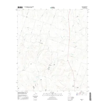
2016 Map of Shive
USGS Topo · Published 2016About this map
Shive and the small settlement of West Point anchor this rural landscape in western Hamilton County. The terrain is defined by a dense network of drainages and named elevations, including Vista Mtn and Little Round Mtn. Local family history and genealogical roots are centered around four distinct burial grounds: Perkins Cem, West Point Cem, New Hope Cem, and Little Cowhouse Cem. The area’s geography is deeply eroded, as evidenced by numerous named hollows such as Blackburn Hollow, Snake Hollow, and Whitlock Hollow. Water resources are largely seasonal or localized, with Cowhouse Cr and Little Cowhouse Cr cutting through the northern reaches, while Caldwell Lake Number 1 and Caldwell Lake Number 2 provide critical catchments in the south. The road network, including FM 221 and FM 2414, follows the natural contours of the ridges and valleys between these prominent hills and watercourses.
Find a feature on this map
57 named features on this map. Tap any name to fly to it.
Don’t see what you’re looking for? This feature index may not catch every label — zoom into the map to look around manually.
Map Details
Editions of this 2016 Shive Map
This is the sole edition of this map. No revisions or reprints were ever made.
Other maps of this area

1887 · Lampasas
USGS Topo · 1:125,000

1888 · Hamilton
USGS Topo · 1:125,000

1894 · Hamilton
USGS Topo · 1:125,000

1894 · Lampasas
USGS Topo · 1:125,000

1954 · Brownwood
USGS Topo · 1:250,000

1954 · Evant
USGS Topo · 1:62,500

1954 · Evant
USGS Topo · 1:24,000
1954 · Pearl
USGS Topo · 1:24,000

1956 · Pottsville
USGS Topo · 1:62,500
1956 · Ohio
USGS Topo · 1:24,000