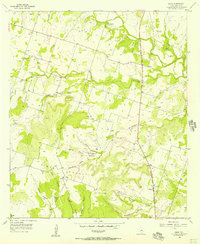
1956 Map of Shive
USGS Topo · Published 1957About this map
Vista Mountain and the high ground of Little Round Mountain dominate this central Texas landscape in the mid-1950s. The settlement of Shive and the community at Schoolerville are centers of local life, connected by a network of drainage systems like Cowhouse Creek and Partridge Creek. The era's transportation is anchored by the north-south route of the American Legion Memorial Highway, which cuts through the undulating terrain near Henderson Creek.
Find a feature on this map
32 named features on this map. Tap any name to fly to it.
Don’t see what you’re looking for? This feature index may not catch every label — zoom into the map to look around manually.
Map Details
Editions of this 1956 Shive Map
This is the sole edition of this map. No revisions or reprints were ever made.
Other maps of this area

1887 · Lampasas
USGS Topo · 1:125,000

1888 · Hamilton
USGS Topo · 1:125,000

1894 · Hamilton
USGS Topo · 1:125,000

1894 · Lampasas
USGS Topo · 1:125,000

1954 · Brownwood
USGS Topo · 1:250,000

1954 · Evant
USGS Topo · 1:62,500

1954 · Evant
USGS Topo · 1:24,000
1954 · Pearl
USGS Topo · 1:24,000

1956 · Pottsville
USGS Topo · 1:62,500
1956 · Ohio
USGS Topo · 1:24,000