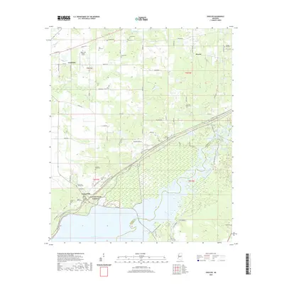
2020 Map of Shoccoe
USGS Topo · Published 2020About this map
Madisonville and the rural community of Shoccoe sit at the intersection of modern recreational infrastructure and deep Mississippi history in this 2020 survey. The landscape is defined by the Natchez Trace Pkwy and the Natchez Trace National Scenic Trail, which cut a diagonal path across the terrain toward the expansive Ross R Barnett Reservoir and the Pearl River. This confluence of water and historic transit routes has preserved a remarkable number of family burial sites and small churchyards, including the Galloway Family Cem, Zion Chapel Cem, and Madisonville - Holland Cem. To the north, the outskirts of Canton give way to a network of creeks like Tilda Bogue and Walnut Cr. The map captures the area's transition from the residential clusters of Eagle Crest Estates Airport to the marshes of Tupelo Gum Slough and the Goshen Springs Campground.
Find a feature on this map
56 named features on this map. Tap any name to fly to it.
Don’t see what you’re looking for? This feature index may not catch every label — zoom into the map to look around manually.
Map Details
Editions of this 2020 Shoccoe Map
This is the sole edition of this map. No revisions or reprints were ever made.
Other maps of this area

1903 · Jackson
USGS Topo · 1:125,000

1905 · Jackson
USGS Topo · 1:48,000

1908 · Jackson
USGS Topo · 1:62,500

1922 · Pelahatchee
USGS Topo · 1:48,000

1924 · Pelahatchee
USGS Topo · 1:62,500

1950 · Pelahatchie
USGS Topo · 1:62,500

1952 · Pelahatchie
USGS Topo · 1:62,500

1953 · Meridian
USGS Topo · 1:250,000

1955 · Jackson
USGS Topo · 1:250,000

1957 · Meridian
USGS Topo · 1:250,000