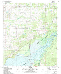
1989 Map of Shoccoe
USGS Topo · Published 1989About this map
Ross Barnett Reservoir and the Pearl River dominate this Central Mississippi landscape, defining the watery boundary between Madison and Rankin counties. The 1989 revision highlights the vast environmental conservation areas, including the Pearl River State Waterfowl Refuge and the Pearl River State Wildlife Management Area, which protect the wetlands and sloughs like Tupelo Gum Slough.
Find a feature on this map
44 named features on this map. Tap any name to fly to it.
Don’t see what you’re looking for? This feature index may not catch every label — zoom into the map to look around manually.
Map Details
Editions of this 1989 Shoccoe Map
This is the sole edition of this map. No revisions or reprints were ever made.
Other maps of this area

1903 · Jackson
USGS Topo · 1:125,000

1905 · Jackson
USGS Topo · 1:48,000

1908 · Jackson
USGS Topo · 1:62,500

1922 · Pelahatchee
USGS Topo · 1:48,000

1924 · Pelahatchee
USGS Topo · 1:62,500

1950 · Pelahatchie
USGS Topo · 1:62,500

1952 · Pelahatchie
USGS Topo · 1:62,500

1953 · Meridian
USGS Topo · 1:250,000

1955 · Jackson
USGS Topo · 1:250,000

1957 · Meridian
USGS Topo · 1:250,000