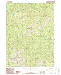
1986 Map of Shoeinhorse Mountain
USGS Topo · Published 1986About this map
The Mc Cloud River carves through the northern reaches of this landscape, serving as a primary corridor for early transit and recreation. Small outposts like Ash Camp and Sheep Camp reflect a history of seasonal usage within the expansive Shasta National Forest. The terrain is characterized by prominent peaks and ridges, including Shoeinhorse Mtn and Little Shoeinhorse Mtn, which overlook a complex network of drainages such as Squaw Creek and Hawkins Creek.
Find a feature on this map
50 named features on this map. Tap any name to fly to it.
Don’t see what you’re looking for? This feature index may not catch every label — zoom into the map to look around manually.
Map Details
Editions of this 1986 Shoeinhorse Mountain Map
This is the sole edition of this map. No revisions or reprints were ever made.
Other maps of this area

1886 · Lassen Peak
USGS Topo · 1:250,000

1886 · Modoc Lava Bed
USGS Topo · 1:250,000

1886 · Shasta
USGS Topo · 1:250,000

1890 · Red Bluff
USGS Topo · 1:250,000

1892 · Modoc Lava-Bed
USGS Topo · 1:250,000

1892 · Lassen Peak
USGS Topo · 1:250,000

1894 · Lassen Peak
USGS Topo · 1:250,000

1894 · Red Bluff
USGS Topo · 1:250,000

1894 · Shasta
USGS Topo · 1:250,000

1901 · Redding
USGS Topo · 1:125,000