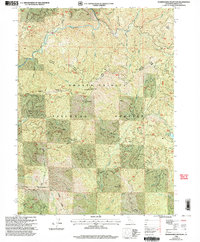
1998 Map of Shoeinhorse Mountain
USGS Topo · Published 2003About this map
Mc Cloud River flows through the northern reaches of this landscape, a region defined by high ridges and remote encampments within the Shasta-Trinity National Forest. The 1998 revision of the area shows the path of the Pacific Crest National Scenic Trail as it skirts the river valley near Ash Camp and Ghost Camp. The terrain is punctuated by significant volcanic and mountain features, from Shoeinhorse Mtn and its lower neighbor Little Shoeinhorse Mtn to the prominent Coyote Peak in the east.
Find a feature on this map
43 named features on this map. Tap any name to fly to it.
Don’t see what you’re looking for? This feature index may not catch every label — zoom into the map to look around manually.
Map Details
Editions of this 1998 Shoeinhorse Mountain Map
This is the sole edition of this map. No revisions or reprints were ever made.
Other maps of this area

1886 · Lassen Peak
USGS Topo · 1:250,000

1886 · Modoc Lava Bed
USGS Topo · 1:250,000

1886 · Shasta
USGS Topo · 1:250,000

1890 · Red Bluff
USGS Topo · 1:250,000

1892 · Modoc Lava-Bed
USGS Topo · 1:250,000

1892 · Lassen Peak
USGS Topo · 1:250,000

1894 · Lassen Peak
USGS Topo · 1:250,000

1894 · Red Bluff
USGS Topo · 1:250,000

1894 · Shasta
USGS Topo · 1:250,000

1901 · Redding
USGS Topo · 1:125,000