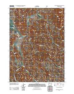
2011 Map of Shoestring Butte
USGS Topo · Published 2011About this map
Gaylord Ranch and the headwaters of the Chewaucan River define this high-desert landscape in Lake County. The terrain is a complex network of volcanic buttes and seasonal drainages, where water sources like Paddy Spring, Schuster Spring, and Clem Spring provide critical points of reference in an arid environment. The map details the intricate topography surrounding Shoestring Butte and the distinctive Jack and Jenny Buttes, illustrating the rugged drainage patterns of Swamp Creek and Shoestring Creek. The layout of forestry roads and cattle-ranching infrastructure reflects the land's contemporary use for grazing and timber management, highlighting the balance between high-altitude passes like Round Pass and the low-lying basins of Dairy Creek.
Find a feature on this map
22 named features on this map. Tap any name to fly to it.
Don’t see what you’re looking for? This feature index may not catch every label — zoom into the map to look around manually.
Map Details
Editions of this 2011 Shoestring Butte Map
This is the sole edition of this map. No revisions or reprints were ever made.
Other maps of this area

1955 · Klamath Falls
USGS Topo · 1:250,000

1958 · Klamath Falls
USGS Topo · 1:250,000

1964 · Cox Flat
USGS Topo · 1:24,000

1964 · Coleman Point
USGS Topo · 1:24,000

1964 · Cougar Peak
USGS Topo · 1:24,000

1964 · Shoestring Butte
USGS Topo · 1:24,000

1964 · Clover Flat
USGS Topo · 1:24,000

1964 · Big Baldy
USGS Topo · 1:24,000

1966 · Morgan Butte
USGS Topo · 1:24,000

1966 · Tucker Hill
USGS Topo · 1:24,000