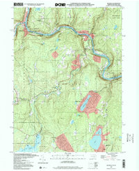
1997 Map of Shohola
USGS Topo · Published 2000About this map
Lackawaxen and the adjacent Delaware River serve as the centerpiece for this Northeastern Pennsylvania landscape, where historical infrastructure and conservation efforts intersect. The presence of the Roebling Bridge and the Zane Grey Museum near the confluence of the Lackawaxen River highlights the area's transition from a working river valley to a site of cultural preservation. To the north, the Minisink Battlefield County Park Monument commemorates local Revolutionary War history, while the sprawling State Game Lands No 116 and State Game Lands No 180 indicate the shift toward protected recreation and wildlife management.
Find a feature on this map
60 named features on this map. Tap any name to fly to it.
Don’t see what you’re looking for? This feature index may not catch every label — zoom into the map to look around manually.
Map Details
Editions of this 1997 Shohola Map
This is the sole edition of this map. No revisions or reprints were ever made.
Other maps of this area

1913 · Milford
USGS Topo · 1:62,500

1915 · Milford
USGS Topo · 1:62,500

1920 · Damascus
USGS Topo · 1:62,500

1922 · White Lake
USGS Topo · 1:62,500

1923 · Damascus
USGS Topo · 1:62,500

1935 · Hawley
USGS Topo · 1:62,500

1938 · Hawley
USGS Topo · 1:62,500

1942 · White Lake
USGS Topo · 1:62,500

1943 · Honesdale
USGS Topo · 1:125,000

1943 · White Lake
USGS Topo · 1:62,500