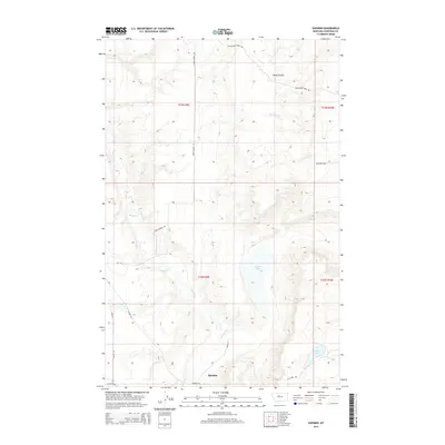
2014 Map of Shonkin
USGS Topo · Published 2014About this map
Shonkin sits at the foot of the Highwood Mountains' northern slopes, where the plains of Chouteau County begin to roll toward the Missouri River valley. The settlement is defined by its relationship to the local watercourses, specifically Shonkin Cr, which winds through the lower half of the map. The landscape is marked by unique glacial features, most notably the large basin of Shonkin Lake and the nearby Sand Lake, both situated in an area of complex coulees and ridges. The road network, including Rode School Rd and Frenchman Ridge Rd, follows the natural contours of the terrain, illustrating how land use in this part of Montana remains tied to the local topography and the drainage patterns of Boyle Coulee.
Find a feature on this map
19 named features on this map. Tap any name to fly to it.
Don’t see what you’re looking for? This feature index may not catch every label — zoom into the map to look around manually.
Map Details
Editions of this 2014 Shonkin Map
This is the sole edition of this map. No revisions or reprints were ever made.
Other maps of this area

1890 · Fort Benton
USGS Topo · 1:250,000

1892 · Fort Benton
USGS Topo · 1:250,000

1897 · Fort Benton
USGS Topo · 1:250,000

1953 · Rocky Lake
USGS Topo · 1:24,000

1953 · O'Hanlon Coulee
USGS Topo · 1:24,000

1954 · Great Falls
USGS Topo · 1:250,000

1954 · Fort Benton
USGS Topo · 1:24,000

1957 · Great Falls
USGS Topo · 1:250,000
1972 · Montague
USGS Topo · 1:24,000
1972 · Shonkin NW
USGS Topo · 1:24,000