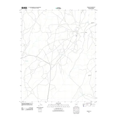
2011 Map of Shonto
USGS Topo · Published 2011About this map
Shonto serves as the primary hub of this high-desert landscape in Navajo County, where a network of Bureau of Indian Affairs routes crisscross the terrain. The community is defined by its relationship with vital water sources in an arid environment, notably Shonto Spring and the curiously named Starting of the Water Spring. To the northeast, the drainage of John Smith Wash cuts through the plateaus, while Saneneheck Rock stands as a prominent natural landmark to the southeast. A intricate web of roads, including Indian Rte-6320 and Indian Rte-221, connects scattered residential clusters and administrative buildings, illustrating the modern settlement patterns and infrastructure of the Navajo Nation during the early twenty-first century.
Find a feature on this map
13 named features on this map. Tap any name to fly to it.
Don’t see what you’re looking for? This feature index may not catch every label — zoom into the map to look around manually.
Map Details
Editions of this 2011 Shonto Map
This is the sole edition of this map. No revisions or reprints were ever made.
Other maps of this area

1883 · Marsh Pass
USGS Topo · 1:250,000

1892 · Marsh Pass
USGS Topo · 1:250,000

1956 · Marble Canyon
USGS Topo · 1:250,000

1959 · Marble Canyon
USGS Topo · 1:250,000

1961 · Marble Canyon
USGS Topo · 1:250,000

1970 · Cow Springs
USGS Topo · 1:24,000

1970 · Black Mesa Wash NW
USGS Topo · 1:24,000

1970 · Whirlwind Rock
USGS Topo · 1:24,000

1970 · Shonto SE
USGS Topo · 1:24,000
1970 · Betatakin Ruin
USGS Topo · 1:24,000