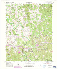
1952 Map of Shopville
USGS Topo · Published 1987About this map
Buck Creek and its many winding tributaries, including Fish Trap Creek and Brushy Creek, define the topography of this Pulaski County region. The landscape is marked by a high density of rural schoolhouses and family cemeteries, reflecting a deeply rooted community structure in the early 1950s. Small hamlets like Shopville and Stab serve as local hubs, while educational life is represented by numerous numbered and named institutions such as Burdine Sch No 1, Burdine Sch No 2, and Silver Star Sch.
Find a feature on this map
84 named features on this map. Tap any name to fly to it.
Don’t see what you’re looking for? This feature index may not catch every label — zoom into the map to look around manually.
Map Details
Editions of this 1952 Shopville Map
2 editions found
Other maps of this area

1893 · London
USGS Topo · 1:125,000

1897 · London
USGS Topo · 1:125,000

1935 · Somerset
USGS Topo · 1:62,500

1952 · Billows
USGS Topo · 1:24,000

1952 · Ano
USGS Topo · 1:24,000

1952 · Dykes
USGS Topo · 1:24,000

1952 · Shopville
USGS Topo · 1:24,000

1952 · Woodstock
USGS Topo · 1:24,000

1953 · Maretburg
USGS Topo · 1:24,000

1953 · Mount Vernon
USGS Topo · 1:24,000