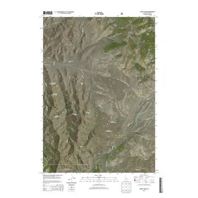
2013 Map of Short Creek
USGS Topo · Published 2013About this map
Challis National Forest land dominates this high-altitude landscape in central Idaho, where numerous water sources sustain the mountain terrain. The map identifies several numbered and named water points, such as Short Creek Spring Number 1, Middle Spring, and Dry Creek Spring Number 1, indicating the critical importance of localized hydrology in these uplands. Distinctive geological landmarks rise above the drainage basins, including the curiously named Squawtit, the prominent Garrett Rock, and the Rock of Ages in the southwest quadrant. The primitive transit network is defined by unpaved routes like Burnt Creek Rd and Dry Creek Rd, which provide access to the drainages of Elkhorn Cr and Long Cr. This 2013 survey provides a clear view of the backcountry environment before modern developments, showing the distribution of seasonal water at Buck Springs and the drainage patterns of the Donkey Hills.
Find a feature on this map
32 named features on this map. Tap any name to fly to it.
Don’t see what you’re looking for? This feature index may not catch every label — zoom into the map to look around manually.
Map Details
Editions of this 2013 Short Creek Map
This is the sole edition of this map. No revisions or reprints were ever made.
Other maps of this area

1935 · Borah Peak
USGS Topo · 1:125,000

1938 · Borah Peak
USGS Topo · 1:125,000

1955 · Dubois
USGS Topo · 1:250,000

1956 · Donkey Hills
USGS Topo · 1:62,500

1957 · Gilmore
USGS Topo · 1:62,500

1957 · Hawley Mountain
USGS Topo · 1:62,500

1958 · Dubois
USGS Topo · 1:250,000
1962 · Leatherman Peak
USGS Topo · 1:24,000
1967 · Massacre Mtn
USGS Topo · 1:24,000
1967 · Burnt Creek
USGS Topo · 1:24,000