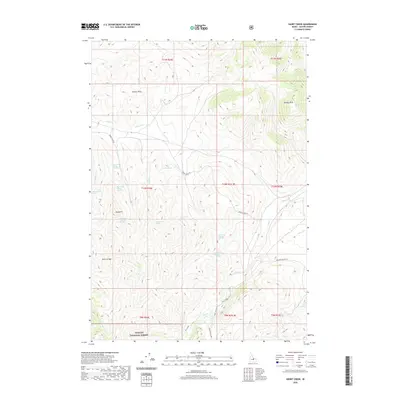
2020 Map of Short Creek
USGS Topo · Published 2020About this map
Challis National Forest land defines this Custer County interior, where a network of water sources supports the high-elevation landscape. The terrain is marked by distinctive high points such as Garrett Rock, Squawit, and the Donkey Hills. A complex system of natural springs, including Middle Spring, Iron Spring, and multiple numbered sites like Short Creek Spring Number 1 and Dry Creek Spring Number 2, indicates the critical role of water management in this part of Idaho. Transportation is limited to rugged corridors like Burnt Creek Rd and Nat For Dev Rd 119, which navigate the drainages of Long Lost Creek and Elkhorn Cr. The map reveals a remote territory of named geological features like the Rock of Ages, offering a clear view of the survey lines and topographic shifts across these national forest lands.
Find a feature on this map
35 named features on this map. Tap any name to fly to it.
Don’t see what you’re looking for? This feature index may not catch every label — zoom into the map to look around manually.
Map Details
Editions of this 2020 Short Creek Map
This is the sole edition of this map. No revisions or reprints were ever made.
Other maps of this area

1935 · Borah Peak
USGS Topo · 1:125,000

1938 · Borah Peak
USGS Topo · 1:125,000

1955 · Dubois
USGS Topo · 1:250,000

1956 · Donkey Hills
USGS Topo · 1:62,500

1957 · Gilmore
USGS Topo · 1:62,500

1957 · Hawley Mountain
USGS Topo · 1:62,500

1958 · Dubois
USGS Topo · 1:250,000
1962 · Leatherman Peak
USGS Topo · 1:24,000
1967 · Massacre Mtn
USGS Topo · 1:24,000
1967 · Burnt Creek
USGS Topo · 1:24,000