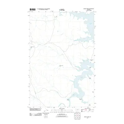
2011 Map of Short Creek
USGS Topo · Published 2011About this map
Fort Peck Lake defines the eastern boundary of this McCone County landscape, where the Missouri River drainage meets the rugged coulees and flats of eastern Montana. The map illustrates the complex shoreline of the reservoir, including distinct features like North Twitchell Point and Stubby Point. In this arid ranching country, the management of water is evident through the placement of stock reservoirs such as Twitchell Number 2 Dam and Claribell Number 11 Dam.
Find a feature on this map
18 named features on this map. Tap any name to fly to it.
Don’t see what you’re looking for? This feature index may not catch every label — zoom into the map to look around manually.
Map Details
Editions of this 2011 Short Creek Map
This is the sole edition of this map. No revisions or reprints were ever made.
Other maps of this area

1954 · Jordan
USGS Topo · 1:250,000

1956 · Jordan
USGS Topo · 1:250,000

1958 · Jordan
USGS Topo · 1:250,000

1964 · Jordan
USGS Topo · 1:250,000

1967 · Hagen Gap
USGS Topo · 1:24,000

1967 · Frank Coulee
USGS Topo · 1:24,000

1972 · Short Creek
USGS Topo · 1:24,000

1972 · Flat Creek School
USGS Topo · 1:24,000

1972 · Ash Creek East
USGS Topo · 1:24,000
1972 · Ash Creek West
USGS Topo · 1:24,000