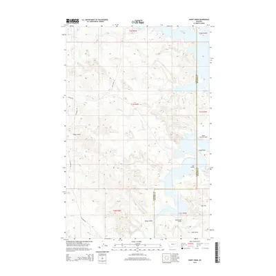
2014 Map of Short Creek
USGS Topo · Published 2014About this map
Fort Peck Lake dominates the eastern reaches of this Garfield and McCone County landscape, where the Missouri River's impoundment creates a complex shoreline of points and recessed coulees. The terrain is defined by its drainage into the lake through systems like Short Creek and Snap Creek, while the western portion is traversed by Van Norman Road. This area, deeply carved by erosional features, showcases the intersection of the vast prairie and the artificial shoreline. Geographic landmarks such as North Twitchell Point and Stubby Point mark the interface between the dry uplands and the water. To the south, Big Dry Creek feeds into the reservoir near Bridge Coulee, illustrating the sparse, water-dependent geography of eastern Montana during this early 21st-century period.
Find a feature on this map
23 named features on this map. Tap any name to fly to it.
Don’t see what you’re looking for? This feature index may not catch every label — zoom into the map to look around manually.
Map Details
Editions of this 2014 Short Creek Map
This is the sole edition of this map. No revisions or reprints were ever made.
Other maps of this area

1954 · Jordan
USGS Topo · 1:250,000

1956 · Jordan
USGS Topo · 1:250,000

1958 · Jordan
USGS Topo · 1:250,000

1964 · Jordan
USGS Topo · 1:250,000

1967 · Hagen Gap
USGS Topo · 1:24,000

1967 · Frank Coulee
USGS Topo · 1:24,000

1972 · Short Creek
USGS Topo · 1:24,000

1972 · Flat Creek School
USGS Topo · 1:24,000

1972 · Ash Creek East
USGS Topo · 1:24,000
1972 · Ash Creek West
USGS Topo · 1:24,000