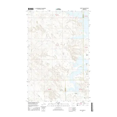
2017 Map of Short Creek
USGS Topo · Published 2017About this map
Lone Tree Cr and Snap Cr carve through this section of the Missouri River breaks at the border of McCone and Garfield counties. The landscape is defined by its dramatic drainage patterns, where coulees like Shot Coulee and Mendenhall Coulee descend toward the expansive waters of the Dry Arm. This territory remains sparsely developed, with land use largely confined to the cattle-ranching operations indicated by the network of unpaved tracks such as Van Norman Rd and Rock Barn Rd. Prominent landmarks like North Twitchell Point and Stubby Point overlook the shoreline, while Egan Flat provides a rare area of level ground amidst the broken terrain. The map's layout of section lines and township boundaries, including t21n r42e, illustrates the enduring influence of the Public Land Survey System on Montana's rural geography.
Find a feature on this map
23 named features on this map. Tap any name to fly to it.
Don’t see what you’re looking for? This feature index may not catch every label — zoom into the map to look around manually.
Map Details
Editions of this 2017 Short Creek Map
This is the sole edition of this map. No revisions or reprints were ever made.
Other maps of this area

1954 · Jordan
USGS Topo · 1:250,000

1956 · Jordan
USGS Topo · 1:250,000

1958 · Jordan
USGS Topo · 1:250,000

1964 · Jordan
USGS Topo · 1:250,000

1967 · Hagen Gap
USGS Topo · 1:24,000

1967 · Frank Coulee
USGS Topo · 1:24,000

1972 · Short Creek
USGS Topo · 1:24,000

1972 · Flat Creek School
USGS Topo · 1:24,000

1972 · Ash Creek East
USGS Topo · 1:24,000
1972 · Ash Creek West
USGS Topo · 1:24,000