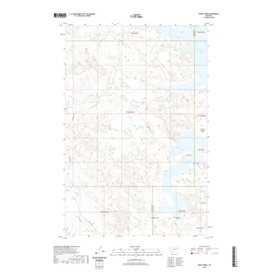
2020 Map of Short Creek
USGS Topo · Published 2020About this map
Fort Peck Lake dominates the eastern horizon of this McCone County landscape, with its irregular shoreline forming Dry Arm and extending past North Twitchell Point. The terrain is defined by a dense network of coulees and flats that drain toward the reservoir, including Shot Coulee, Mendenhall Coulee, and Egan Coulee. This 2020 survey illustrates a sparsely populated ranching region where long-distance routes like Van Norman Rd and Rock Barn Rd provide the primary access through the drainage basins of Lone Tree Cr and Short Cr. The boundary between Garfield and McCone counties runs north-south through the center of the lake's western reach, marking a transition from the elevated Stubby Point down to the alluvial Egan Flat in the southeast corner.
Find a feature on this map
18 named features on this map. Tap any name to fly to it.
Don’t see what you’re looking for? This feature index may not catch every label — zoom into the map to look around manually.
Map Details
Editions of this 2020 Short Creek Map
This is the sole edition of this map. No revisions or reprints were ever made.
Other maps of this area

1954 · Jordan
USGS Topo · 1:250,000

1956 · Jordan
USGS Topo · 1:250,000

1958 · Jordan
USGS Topo · 1:250,000

1964 · Jordan
USGS Topo · 1:250,000

1967 · Hagen Gap
USGS Topo · 1:24,000

1967 · Frank Coulee
USGS Topo · 1:24,000

1972 · Short Creek
USGS Topo · 1:24,000

1972 · Flat Creek School
USGS Topo · 1:24,000

1972 · Ash Creek East
USGS Topo · 1:24,000
1972 · Ash Creek West
USGS Topo · 1:24,000