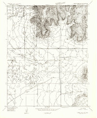
1954 Map of Short Creek NW
USGS Topo · Published 1956About this map
Short Creek and the surrounding high desert of the Arizona Strip are documented here just before the mid-1950s. The landscape is defined by the massive escarpment of the Vermilion Cliffs, where dramatic landmarks like Cottonwood Point and Lyons Point overlook the lower basins. The settlement at Short Creek is shown with its early grid of structures and a small Cem, while to the southeast, the ranching outpost of Cane Beds sits near the mouth of Scott Canyon.
Find a feature on this map
16 named features on this map. Tap any name to fly to it.
Don’t see what you’re looking for? This feature index may not catch every label — zoom into the map to look around manually.
Map Details
Editions of this 1954 Short Creek NW Map
This is the sole edition of this map. No revisions or reprints were ever made.
Other maps of this area

1885 · St. George
USGS Topo · 1:250,000

1886 · Kanab
USGS Topo · 1:250,000

1886 · Mt. Trumbull
USGS Topo · 1:250,000

1886 · Kaibab
USGS Topo · 1:250,000

1891 · St. George
USGS Topo · 1:250,000

1892 · Mt. Trumbull
USGS Topo · 1:250,000

1953 · Cedar City
USGS Topo · 1:250,000

1953 · Grand Canyon
USGS Topo · 1:250,000

1954 · La Verkin 4 SE
USGS Topo · 1:24,000

1954 · Lost Spring SE
USGS Topo · 1:24,000