1970 Map of Show Low North
USGS Topo · Published 1973About this map
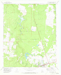
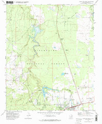
Sitgreaves National Forest dominates the landscape of this 1970 survey, where the Mogollon Rim's drainage patterns are clearly defined by Show Low Creek and its various tributaries. The town of Show Low is visible in the lower portion of the map, showing its mid-century footprint organized along Adams St and Cooley St, including the local cemetery and Rodeo Grounds. Public infrastructure and recreation are central to the area's development during this era, evidenced by the Show Low Municipal Airport and the establishment of the Fools Hollow Campground near the waters of Fools Hollow Lake. The map also documents historical transit points and land use, such as Roundy Crossing and Robinson Trail Crossing, alongside more modern additions like the Radio Tower (KVSL) and a developing Trailer Park.
Find a feature on this map
53 named features on this map. Tap any name to fly to it.
Don’t see what you’re looking for? This feature index may not catch every label — zoom into the map to look around manually.
Map Details
Editions of this 1970 Show Low North Map
2 editions found
Other maps of this area

1886 · St Johns
USGS Topo · 1:250,000

1886 · Holbrook
USGS Topo · 1:250,000

1892 · St Johns
USGS Topo · 1:250,000

1893 · Holbrook
USGS Topo · 1:250,000

1954 · Holbrook
USGS Topo · 1:250,000

1954 · Saint Johns
USGS Topo · 1:250,000

1957 · Holbrook
USGS Topo · 1:250,000

1957 · Saint Johns
USGS Topo · 1:250,000

1958 · Saint Johns
USGS Topo · 1:250,000

1958 · Holbrook
USGS Topo · 1:250,000