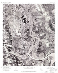
1975 Map of Shreveport East
USGS Topo · Published 1976About this map
Red River oxbows and sediment deposits dominate this mid-1970s orthophotograph, providing a clear photographic look at the hydrological patterns between Shreveport and Bossier City. To the west, the dense urban and residential layout of Shreveport spreads toward the riverbank, while the northeastern portion of the sheet is occupied by the expansive runways and infrastructure of Barksdale Air Force Base. The aerial perspective reveals the complexity of the river's channel, showing numerous sandbars and former meanders that contrast with the organized grid of the neighboring cities. This visual record captures the mid-century expansion of these twin cities as they navigated the constraints and opportunities of the Louisiana floodplain.
Find a feature on this map
4 named features on this map. Tap any name to fly to it.
Don’t see what you’re looking for? This feature index may not catch every label — zoom into the map to look around manually.
Map Details
Editions of this 1975 Shreveport East Map
This is the sole edition of this map. No revisions or reprints were ever made.
Other maps of this area

1932 · Bossier SE
USGS Topo · 1:31,680

1932 · Bossier SW
USGS Topo · 1:31,680

1932 · Shreveport SE
USGS Topo · 1:31,680

1938 · Arnsberg
USGS Topo · 1:31,680

1941 · Forbing
USGS Topo · 1:31,680

1945 · Greenwood
USGS Topo · 1:62,500

1948 · Mooringsport
USGS Topo · 1:62,500

1948 · Bossier City
USGS Topo · 1:62,500

1948 · Caspiana
USGS Topo · 1:62,500

1955 · Shreveport
USGS Topo · 1:250,000