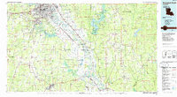
1985 Map of Shreveport South
USGS Topo · Published 1985About this map
The Red River valley serves as the central artery for this mid-1980s landscape, connecting the urban expansion of Shreveport and Bossier City with the agricultural and industrial interior. Significant infrastructure like Barksdale Air Force Base and the Sligo Oil and Gas Field reflect the regional importance of defense and energy. A dense network of railways, including the Kansas City Southern RR and Illinois Central Gulf RR, ties together rural parishes and smaller settlements such as Mansfield, Coushatta, and Ringgold. The terrain is defined by a complex system of waterways and bayous, notably Lake Bistineau and Smithport Lake, which create a fragmented landscape of points and islands like Sunny Point and Hog Island. Toward the southeast, the timberlands of the Kisatchie National Forest contrast with the riparian corridors of the river basin.
Find a feature on this map
116 named features on this map. Tap any name to fly to it.
Don’t see what you’re looking for? This feature index may not catch every label — zoom into the map to look around manually.
Map Details
Editions of this 1985 Shreveport South Map
2 editions found
Other maps of this area

1932 · Bossier SE
USGS Topo · 1:31,680

1932 · Bossier SW
USGS Topo · 1:31,680

1932 · Shreveport SE
USGS Topo · 1:31,680

1937 · Campti NE
USGS Topo · 1:31,680

1937 · Campti NW
USGS Topo · 1:31,680

1938 · Chemard Lake
USGS Topo · 1:31,680

1938 · Lake End
USGS Topo · 1:31,680

1938 · Arnsberg
USGS Topo · 1:31,680

1941 · East Point
USGS Topo · 1:31,680

1941 · Forbing
USGS Topo · 1:31,680