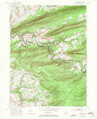
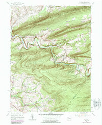
1955 Map of Shumans
USGS Topo · Published 1971About this map
The winding course of Catawissa Creek cuts through a landscape defined by sharp ridges and deep hollows during the mid-1950s. Small rural communities like Shumans, Mainville, and Mifflin Cross Roads are connected by a network of local roads and the infrastructure of the Reading Railroad, which snakes through the valley following the water's edge. The industrial and agricultural heritage of the region is evident in landmarks like Full Mill Hill and the presence of scattered rural institutions, including Harkens Ch and Beaver Sch.
Find a feature on this map
32 named features on this map. Tap any name to fly to it.
Don’t see what you’re looking for? This feature index may not catch every label — zoom into the map to look around manually.
Map Details
Editions of this 1955 Shumans Map
5 editions found
Other maps of this area

1889 · Catawissa
USGS Topo · 1:62,500

1892 · Catawissa
USGS Topo · 1:62,500

1892 · Mahanoy
USGS Topo · 1:62,500

1893 · Mahanoy
USGS Topo · 1:62,500

1894 · Catawissa
USGS Topo · 1:62,500

1894 · Shickshinny
USGS Topo · 1:62,500

1894 · Bloomsburg
USGS Topo · 1:62,500

1946 · Berwick
USGS Topo · 1:31,680

1947 · Bloomsburg
USGS Topo · 1:24,000

1947 · Ashland
USGS Topo · 1:24,000
Featured Places
- North Union Township, PA
- Beaver Township, PA
- Locust Township, PA
- Main Township, PA
- Roaring Creek Township, PA