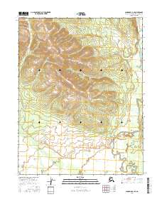
2016 Map of Shungnak C-1 SE
USGS Topo · Published 2016About this map
Pah River dominates the eastern and southern reaches of this interior Alaskan landscape, winding through a complex system of low-lying wetlands and oxbows. The terrain transitions from high, unnamed ridges in the north down toward the Pah River Flats, a broad alluvial expanse that characterizes the southern half of the quadrangle. This area, situated within the Northwest Arctic Borough, showcases the natural drainage patterns of the region before the river turns westward. The map reveals a wild landscape devoid of established roads or permanent settlements, where the geography is defined entirely by its hydrography and elevation contours. This survey serves as a detailed record of the river's course and the surrounding marshlands as they existed in the early twenty-first century.
Find a feature on this map
6 named features on this map. Tap any name to fly to it.
Don’t see what you’re looking for? This feature index may not catch every label — zoom into the map to look around manually.
Map Details
Editions of this 2016 Shungnak C-1 SE Map
This is the sole edition of this map. No revisions or reprints were ever made.
Other maps of this area

1951 · Shungnak
USGS Topo · 1:250,000

1951 · Hughes
USGS Topo · 1:250,000

1955 · Shungnak
USGS Topo · 1:250,000

1956 · Hughes
USGS Topo · 1:250,000

1964 · Shungnak
USGS Topo · 1:250,000

1964 · Hughes
USGS Topo · 1:250,000

1965 · Hughes
USGS Topo · 1:250,000
1985 · Shungnak B-1
USGS Topo · 1:63,360
1985 · Shungnak C-1
USGS Topo · 1:63,360
1986 · Hughes B-6
USGS Topo · 1:63,360