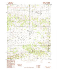
1985 Map of Shungnak C-3
USGS Topo · Published 1985About this map
Sheklukshuk Range and the southern Kiliovilik Range dominate this 1985 survey of the Northwest Arctic. The landscape is defined by these prominent mountain formations, which are separated by the winding course of Kihovilik Creek. This topographic study, based on 1971 aerial photography, captures a portion of the vast wilderness now protected within the Selawik National Wildlife Refuge. The map serves as a primary record of the region's hydrography and elevation before further modern shifts, documenting a remote Alaskan environment where no roads or established trails are noted. The southern half of the sheet is largely occupied by the refuge boundary, illustrating the intersection of federal conservation lands and the natural drainage patterns of the interior.
Find a feature on this map
4 named features on this map. Tap any name to fly to it.
Don’t see what you’re looking for? This feature index may not catch every label — zoom into the map to look around manually.
Map Details
Editions of this 1985 Shungnak C-3 Map
This is the sole edition of this map. No revisions or reprints were ever made.
Other maps of this area

1951 · Shungnak
USGS Topo · 1:250,000

1955 · Shungnak
USGS Topo · 1:250,000

1955 · Shungnak D-4
USGS Topo · 1:63,360

1955 · Shungnak D-2
USGS Topo · 1:63,360

1955 · Shungnak D-3
USGS Topo · 1:63,360

1964 · Shungnak
USGS Topo · 1:250,000

1985 · Shungnak B-4
USGS Topo · 1:63,360
1985 · Shungnak B-3
USGS Topo · 1:63,360
1985 · Shungnak B-2
USGS Topo · 1:63,360
1985 · Shungnak C-2
USGS Topo · 1:63,360